TUE., MAY 21st thru THUR., MAY 30th, 2024
We drove 226 miles northwest mostly on I-87 and arrived at Raton KOA Journey in Raton NM for one night. Temps were a comfy 70 degrees. Quite a change from near 100 degrees yesterday in Amarillo. Along the drive we saw lots of cattle grazing, snow fences, several trains with over 100 freight cars, big silos everywhere and even snow-capped mountains in the distance! The campground was perfectly comfortable for an overnight stay. I even gave Gary a haircut in the afternoon. Now to get used to Mountain Time Zone…
On Wed., May 22nd, (2024) the pod traveled 133 scenic miles from Raton, NM northwest to Cool Sunshine RV Park in Alamosa, CO for 2 nights. Once again, we saw beautiful snow-capped mountains for miles and miles, and lots of snow fences visible across these wide open spaces. We even have a mountain view from our campground. Such a gorgeous part of the country. As an added special bonus we met up with our awesome NH friend Mary here in Alamosa. She will be traveling with us for about 6 weeks in her motor home. So fun to get a NH fix with her visit! Our pod has now increased to 5, and we enjoyed our first Happy Hour together upon arrival! The following day Gary & I did chores, hosted dinner at our tiny home, played golf (card game), and took an evening walk with everyone.
 Raton NM to Alamosa CO


Wow, wow, wow! Gorgeous drive today, Friday, May 24th, (2024) from Alamosa to Mancos, Colorado… 183 miles of snow-capped mountains, lush green forests, cattle ranches and some very mountainous roads with hairpin turns. Kudos to Gary for great driving! Also nice to be parked for a week at Mesa Verde RV Resort. We were supposed to have premium sites, which we booked a year ago. However, our reservations didn’t transfer to this year’s booking system soooo we’re in standard sites which are tighter. Ah well. There are far worse problems we could have. Mary is parked a row over. Let the weekend begin!
 Alamosa to Mancos, CO


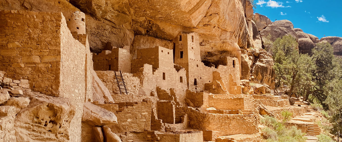
Our expanded pod of five spent 2 days exploring Mesa Verde National Park. Spanish explorers called this area Mesa Verde, or green table, but it is not a true mesa. The landform, a ridge with a steep cliff on one side and a gentle slope on the other is called a cuesta. The park roads were curving and twisting. Our drivers, Gary one day and Cheryl the next, did a great job!
Established by Pres. Theodore Roosevelt in 1906, it’s the only national park in the U.S. created to preserve Ancestral Puebloan cliff dwellings. In addition, there are beautiful CCC (Civilian Conservation Corps) structures in the park that were built during the depression. On a sad note, we also saw remnants of a 2002 fire at Mesa Verde that consumed 2600 acres of trees.
The park is 52,000 acres of amazingness… if that’s a word. There are nearly 5,000 known archeological sites including 600 cliff dwellings. Truly a one-of-a-kind experience to see some of these incredible structures. For over 750 years the pueblo people lived and flourished here, eventually building elaborate stone communities in the sheltered alcoves of canyon walls. In the late 1200s in the span of a generation or two, they left their homes and moved away… just like that a way of life was changed forever.
Our first day we did a 6-mile drive thru Mesa Top Loop making numerous stops at various archeological sites and overlooks. One area was called Knife Edge. There was once a park road in the area, but after repeated collapses the road was moved. We also walked to the highest overlook in the park at 8,572 ft aptly named Park Point Overlook. We were blessed to visit when all the yuccas were blooming!
When looking at some of the original cliff dwellings, we could see hand-and-toe-holds from the bottom floor to the top floor created by the original Native American occupants. I love seeing and learning first hand the history of our country. Just amazing.


The second day in Mesa Verde NP we did a Ranger led tour down into the largest of the cliff dwellings called Cliff Palace, which has 150 rooms and 21 kivas (gathering spaces). To take part in the tour, it meant a 100-ft descent over uneven stone steps, and climbing four, 8-to-10 ft ladders with a 100-ft vertical climb to exit the site. Totally worth the effort! Many believe that Cliff Palace was originally built to function as a social or gathering place for ceremonies. It’s constructed from sandstone, wooden beams, and mortar made from soil, water and ash. The Ancestral Pueblo people shaped the sandstone blocks, used wooden beams to support structures, and created a durable mortar to bind the stones. Amazing!
It was remarkable to stand here and get a sense of time and space, and realize that hundreds of years ago, until almost 1300 CE, this was home to ancient Native Americans. The fact that today it is still intact for us to see, photograph, and appreciate is beyond astounding to me.
After exploring Cliff Palace we had some energy left to check out Far View Sites, a mesa-top farming community with 5 villages. It was one of the most densely populated areas of the mesa top from 900 CE to about 1300 CE. Nearly 50 villages have been identified within a 1/2 square mile. We explored part of it then called it a day!
“Mesa Verde is a remarkable step back in time to understand how the Native Americans of this region not only survived, but thrived over the centuries… working together to build their communities.” A humbling experience to be here.


Gary took a short video of Cliff Palace. At 150-rooms and 21 kivas, it’s the largest cliff dwelling in North America.
On Tuesday, May 28th (2024), the pod visited the Canyons of the Ancients. It’s a National Monument that encompasses 170,000 acres of high desert in the southwest corner of Colorado and it preserves the greatest density of archeological sites in the US. Over 6,000 sites – up to 100 per square mile – have been recorded so far. A staggering number! We saw a few of them.
First we visited the Anasazi Heritage Center, an excellent museum that serves as a starting point for exploring this area. In addition to artifacts, we saw contemporary art by Stanton Englehart who grew up on the edge of the Great Sage Plain and taught art for 30 years at Fort Lewis College. I loved his work… such vibrant colors on his pieces. We also were able to visit the Escalante Pueblo (village) that was located near the Heritage Center. It was named for the first European visitor to write about it. The central kiva and surrounding structures date back to AD 1120s.
If we were to have driven the entire monument area it would have been 89 miles. We drove part of it. First was 35 miles over roads that were paved then gravel then washboard… to Painted Hand Pueblo, originally a small village of about 20 rooms in AD 1200, now a partial tower remains and ruins. We opted to view from a distance rather than attempt the 3/4 mile hike on a hot day at 6,000 ft elevation.
From there we drove to the 1,000 year old Lowry Pueblo. It was inhabited for 165 years. Average height was 5’1” for females and 5’3” for males. Infant mortality was quite high, and the average life span was 30 years. The Pueblo was named after George Lowry, an early 20th century homesteader. We were able to walk down to a kiva but not inside. All our previous encounters were looking down into a kiva. Fascinating to be at eye level!
Today’s drive took us through the Great Sage Plain, which encompasses more than 1,500 square miles of high, dry, rolling plateau, deeply scored by canyons with lots of farmland. Beautiful and very rugged on gravel, washboard roads (poor Gary). On the drive home we came across a very large field of Utah Sweetvetch. Beautiful!
Another fun day of exploring!


Wednesday, May 29th, (2024), we visited the Four Corners Monument. It’s the only place in the U.S. where four states meet or, stating it more eloquently, “marking the common corner of 4 states” – Colorado, New Mexico, Arizona and Utah. It was established by U.S. Surveyors and Astronomers beginning in 1668 and has been challenged and upheld numerous times in court! The site sits on Navajo tribal land. We stood on the spot where the marker on the ground reads “Four States Here Meet In Freedom Under God.”
We traveled southwest for about an hour from our campground to get there. It was a beautiful ride through a desert landscape with various buttes, valleys, ridges and horses grazing in the distance.
Afterwards we visited Yucca House National Monument… established in 1919. The sign reads “a fine example of a Valley Pueblo…” Maybe that was accurate in 1919 but not so much now! Cheryl had to park the truck in someone’s backyard, then we had to walk thru the spray from a sprinkler to get to the path to walk out and see a partial stone wall which was the only thing left. We continued on the trail to see another falling down relic of a 100-year-old house. Gary stayed behind in the truck to wait this one out!
On the drive back home, Cheryl stopped off to the side of one of the entrances to the Ute Reservation for us to take photos because there were some gorgeous views there. Then we had to watch out for trucks flying down the dirt road from the reservation.
Always interesting what we’ll find! A quiet day tomorrow and then we move on to Utah.
 On the drive over.


Leave a Reply